The Blue-Collar Guide to Running in the East Bay
The Best Climbs of the East Bay
 |
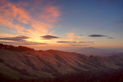
| Looking east from Grizzly Peak Boulevard. Photo: Daniel Parks |
As in the first installment, we've included Strava routes, directions, and bathroom advice. There are also post-run food and drink recommendations...on a blue-collar budget, of course!
1) Mt. Diablo
Contra Costa County
 |
| Mt. Diablo. Photo: WindandFire |
There are several different upward approaches. From the south side of the mountain, Summit Trail will lead you up to the top. There are some really neat rock formations on this trail, but the climb is more exposed and, arguably, a bit less scenic.
 |
| Eagle Peak Trail. Photo: Redwood Hikes |
The last section of climbing on Juniper Trail is exposed. It can be windy and chilly, even in summer. You’ll run through a parking lot before you can see the beacon tower at the top. Make sure you tap the door at the base of the beacon tower or the summit does not count! There are water fountains and bathrooms near the summit. You can take an alternative route down: North Peak trail descends and intersects with Eagle Peak, which returns down to the Mitchell Canyon trailhead.
 |
| The visitor center and beacon tower at the summit. Photo: Mountain Forecast |
Bathrooms: There are plumbing bathrooms and water fountains at the Mitchell Canyon trailhead. There are bathrooms and water at the mountain summit. There are seasonally open bathrooms at the Juniper campground. There is a parking fee at Mitchell Canyon, which requires cash or check.
Strava Route - (for the Mitchell Canyon fire road out & back): 13.5 miles. Vertical gain: 3,360 feet. Average grade: 5%
How To Get There
Mt. Diablo State Park Website.
Post-Run Lunch: Ed’s Mudville Grill - Located near Mitchell Canyon in the town of Clayton, this spot is a local favorite with a sports-bar ambiance. The menu is an extensive array of pub food—burgers, sandwiches, BBQ, etc. It’s a good place to indulge in a burger and a beer. The outdoor patio seating has a leafy Main-Street-America atmosphere. ~$15-20
2) Claremont Canyon
Berkeley, CA
 |
| The view midway up Claremont. Photo: Redwood Hikes |
Located south of UC Berkeley’s campus, the Claremont Canyon path is a remarkable urban fire trail that winds up a steep spine of ridgeline. Featuring pitches up to a 30% grade, Claremont Canyon is a great option if you need accessible vertical close to the East Bay’s urban centers. The trailhead into the Claremont Canyon Regional Preserve is approachable on foot from both north Oakland and downtown Berkeley.
Technically called the "Stonewall-Panoramic Trail," the path begins at the edge of the Clark Kerr campus, a southeast extension of Berkeley’s main campus. After a few mellow switchbacks, the trail pitches audaciously upwards. After some serious uphill, runners reach a gate and some reprieve at a road. Follow this paved section a few hundred meters to where the trail starts up again. At this point, the trail continues with short descents that punctuate super-steep climbing. The uphill finishes in a little grove of trees, about a quarter mile away from Grizzly Peak Boulevard.
Be aware, the footing is a bit treacherous, especially when you descend on your return. There is loose gravel on a few of the steepest pitches, making slide outs possible. So wear shoes with a bit of tread on them.
The trail is a great option for those in Oakland or Berkeley looking to work on their climbing and descending skills without spending an hour in a car. But don’t take my word for it. Hoka One One ultrarunner Chris Denucci used the trail extensively in his buildup to the 2017 Western States Endurance Run, where he finished 5th. Check out one of Denucci’s Claremont Canyon workouts on Strava.
Bathrooms: There is no toilet or water access along the trail. But there are *usually* toilets not far away in the Clark Kerr campus. As of late, portable toilets have been set up north of the trailhead near a volleyball court below the dirt track. There is sometimes a portable toilet on the track itself, but not always. A water fountain is available on the east side of the dirt track.
Strava Route - Distance: 1.9 miles. Vertical gain: 1,410 feet. Average grade: 14%
How To Get There
Claremont Canyon Regional Preserve webpage (includes trail map)
 |
| Photo: Kingfish |
3) The Woodmonster
Oakland, CA
 |
| Madrone Trail. Photo: Author |
The route is not intuitive. The climb starts amid the redwoods on Stream Trail, cutting up Tres Sendas Trail, before a quick left turn onto Star Flower. One then takes a hard left, switchbacking onto French Trail. After a false flat on French, one turns right onto Madrone Trail, which yawps barbarically upwards on a set of rocky steps. This climb is a stout effort.
The Woodmonster Strava segment ends when Madrone Trail intersects with West Ridge Trail (about 200 meters beyond the top of the climb). However, you can add a few more feet of vertical by following a path upward to the very top of Redwood Peak. There’s an interesting sandstone formation up here, with some decades-old graffiti carved.
 |
| Redwood Peak. Photo: David Hodson |
It’s easy to make loops from this climb by running either direction on
West Ridge Trail. If you’re looking to run repeats of the hill, consider
taking Redwood Peak Trail down to French Trail. Turning right on French
will lead you back to Star Flower Trail, where you can run back down to
the start at Stream Trail.
Bathrooms: Can be tricky. There is a toilet in Redwood Bowl about 500 meters from the top of the climb down West Ridge. There nearest toilets at the base of the climb are nearly a mile down Stream Trail toward the park entrance.
Race: The mid-summer Woodmonster Trail Race features the climb during an 8-mile handicapped tour of the park.
Strava Route - Distance: 0.8 miles. Elevation change: 685 feet. Average grade: 14%
How To Get There - You can start nearby (and descend) from here. Or enter the park from Redwood Road ($5 parking fee).
Redwood Regional Park Webpage (includes trail map)
Post-run Breakfast: Check out the Coffee Mill on Grand Avenue for caffeine and a bite. There’s an older feel to the space and it lacks the manicured coziness of second- and third-wave coffee shops. The drip coffee is so-so, but I recommend the Dirty Chai, especially if you’re coming off an early morning workout. There’s a sizable breakfast menu to help start the post-run day. ~$6-14
4) Las Trampas Regional Wilderness
Danville and San Ramon, CA
 |
| Las Trampas Ridge. Photo: Wiki Commons |
Las Trampas is exposed. It is very warm during the summer and muddy during the winter. No surprise that the wilderness was named for the Spanish word for "traps." So bring water.
 |
| The crest of Rocky Ridge Trail. Photo: Nitin Tomar |
If your quads need a thrashing for an upcoming ultramarathon, Las Trampas is an ideal playground. As a reward you'll be treated to incredible views of Mt. Diablo and the surrounding foothills. The Brazen race starts at a staging area at the end of Bollinger Canyon Road, well into the wilderness and a five-mile drive from I-680. There are also trailheads in the neighborhoods west of Danville or San Ramon. Just be mindful of parking restrictions on these residential streets.
Bathrooms: There are portable toilets and drinking water at the staging area off Bollinger Canyon Road.
 |
| Photo: Wiki Commons |
Las Trampas Regional Wilderness webpage (includes trail map)
How To Get There: Danville Suburbs (steep start) or Bollinger Canyon Road
Post-Run Brunch: My affordable-food radar gets dim on this gentrified side of the hills. But I've found Millie's Kitchen outside Lafayette to be a pleasant place to refuel after a run in Contra Costa county. It's a convenient location for those heading back west on Highway 24. The All-American breakfast fare won't appeal to the most smug of foodies, but I like the unpretentious atmosphere and big portions. It you're feeling indulgent try the coffee cake. ~$15-18
5) Tunnel Road
Oakland, CA
 |
| Most of the images of Tunnel Road are from upscale realtors. |
This is an interesting part of the Berkeley/Oakland hills. Much of it was burned during the 1991 Oakland firestorm, which blazed through 1,500 acres, destroying over 3,000 homes. New housing developments have sprung up since the fire, including some pretty funky home designs. The road also passes the old western portal for the original tunnel. Variously called the Kennedy or Broadway Tunnel, a plaque remains at what was once the western portal to the road’s namesake.
The "formal" start of the climb begins at the Oakland Hills Fire Memorial Park. From this point it is almost exactly 5 kilometers to the intersection of Grizzly Peak. Technically, Tunnel Road becomes Skyline Boulevard when you pass over the Caldecott Tunnel (hundreds of feet below you), but there is ample signage (designed for cyclists) that gives you updates about how far you are to the summit.
It is very easy to extend this climb by starting lower at the famous Claremont Hotel, and running up to the turn-off at the Fire Memorial. Be aware, this section of road is highly trafficked, especially during commute hours. There are very few opportunities to safely cross this section of Tunnel/Hwy 13 on foot during rush hour. Make sure you run up the left side of the road, which will lead to the more residential sections of the climb without danger.
 |
| The Claremont Hotel. Photo: Expedia |
Bathrooms: There are no bathrooms at the start of climb. However, on the other side of Highway 24 there are bathrooms at the North Oakland Regional Sports Center. (Map link here).
Strava Segment - Distance: 3 miles. Elevation change: 762 feet. Average grade: 5%
How to Get There
Post-run Coffee: This part of town is a coffee fanatics dream. Follow Claremont Avenue down the hill from the hotel to a cluster of options. Cole Coffee is a neighborhood staple, featuring a social atmosphere and custom-drip cups. If you're feeling peckish go to Spasso, where there are affordable sandwiches, ample table space, and super cheap "day-old" pastries. $4-10
Honorable Mentions:
 |
| The queue at Mission Peak. Photo: Redwood Hikes |
The Cal Fire Trail: We are going to save a lengthier description of the Cal Fire Trail for another installment, but it’s worth noting that the trail begins just east of UC Berkeley’s campus and climbs up the canyon to the top of the ridge line. The trail is a generally mild climb, but it does include the gut-busting “Connector” a 200ish-meter section of trail that zooms up to a 25% grade. Rumor has it that Nike trail running pro Alex Varner once did a session of 20 repeats up and down this beast.
Forgot your Running Shoes?
For shoes, gear, and info on local events and races, check out Transports, the local running store with locations in both Berkeley and Oakland. The store also hosts weekly events around the area, so it is worth signing up for their social media and emails.Special Thanks
A special thank you to Dave Baselt at Redwood Hikes, for allowing use of his photography. Check out his extensive and detailed list of trails and hikes across California. Redwood Hikes has an extensive number of trail maps for sale in print or digital download.
Disagree with this list?
Throw some shade on Twitter toward @SF_RobinsonOr follow me on Strava
And check out East Bay Strava Runners for upcoming local events


Las Trampas is the best. Parking in Alamo is a better option if you're coming from the Hwy 24 direction to cut driving time. Here's a shorter 5mile/1,800 ft route starting in Alamo if you want to maximize killer vert, single track and vistas:
ReplyDeletehttps://www.strava.com/routes/9633526
Note that this route takes you off the beaten fire roads at several points, so care must be taken to stay on the correct trail.
Your blog is very nice,Thanks for sharing.
ReplyDeleteหนังซอมบี้
Your blog is very useful for me,Thanks for your sharing.
ReplyDeleteหนังซอมบี้
Wishing good fortune to everyone who comes across this comment! I went bankrupt last year due to failed business ideas. I used to enjoy playing the lottery for fun but as my situation worsened financially, I sought help to win big this time and found a man called MEDUZA, who has assisted numerous individuals worldwide with their financial issues. This man prepared a powerful spell for me that enabled him to get the secrete lucky numbers for me, I played the game with the numbers and to my astonishment, I discovered that I had won $259 million Jackpot after 2 weeks just has he said; Today, I’m now free of debt and I own different investments globally. Without Meduza, I wouldn’t have made it through the tough times I experienced last year. Truly, MEDUZA is a divine presence among us. If you are currently struggling in aspect of your life, reach out to MEDUZA through the below information's.
ReplyDeleteWhats-App: +1 807 798 3042
Email: lordmeduzatemple@hotmail.com
Face-book Page: Lordmeduza